![]()
“Life shrinks or expands in proportion to one’s courage.” ~Anaïs Nin
When I think back on my life, shyness feels like an inner prison I carried with me for years. Not a prison with bars and guards, but a quieter kind—made of hesitation, fear, and silence. It kept me standing still while life moved forward around me.
One memory stays with me: my eighth-grade dance. The gym was alive with music, kids moving awkwardly but freely on the floor, laughing, bumping into one another, having fun. And there I was in the corner, figuratively stomping paper cups.
That’s how I …
![]()
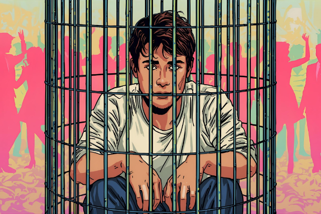
“Life shrinks or expands in proportion to one’s courage.” ~Anaïs Nin
When I think back on my life, shyness feels like an inner prison I carried with me for years. Not a prison with bars and guards, but a quieter kind—made of hesitation, fear, and silence. It kept me standing still while life moved forward around me.
One memory stays with me: my eighth-grade dance. The gym was alive with music, kids moving awkwardly but freely on the floor, laughing, bumping into one another, having fun. And there I was in the corner, figuratively stomping paper cups.
That’s how I remember it—like I was crushing cardboard instead of stepping into life. I can even smile at the image now, but at the time it wasn’t funny. I noticed another girl across the room, also standing alone. She was beautiful. Maybe she was waiting for someone to walk over. But in my mind, she was “out of reach.” My shyness locked me in place, and I never moved.
It wasn’t a dramatic heartbreak—just another reminder of how many moments slipped by.
The Pattern of Missed Chances
That night was only one of many. Over the years I missed far more opportunities than I embraced: the conversations I didn’t start, the invitations I quietly avoided, the women I admired from a distance but never approached.
Shyness never really served me. I hated it, but it was powerful. I carried it into my adult years, and though I fought hard to loosen its grip, it shaped how I lived and related. Over time I changed; I’d call myself “reserved” now rather than painfully shy. But the shadow is still there.
Shyness as a Prison
Shyness isn’t just being quiet. It’s a whole system of fear and self-consciousness: fear in the body, doubt in the mind, and inaction in the world. It feels like safety, but it’s really confinement. It builds walls between you and the very connections you long for.
I’ve come to see shyness as a kind of “social yips.” Just as an athlete suddenly freezes when overthinking the simplest movement, I froze in moments of connection. I knew what I wanted to do, but my body wouldn’t follow. And like the yips, the more I thought about it, the worse it became. Buddhism later helped me see that the way through wasn’t forcing myself harder but loosening my grip—letting go of self-judgment and stepping into presence.
Zorba and the Choice to Say Yes
As I look back, I know not every missed chance would have been good for me. Sometimes the lure of conquest was more about ego than true connection, and saying no spared me mistakes.
But there’s another kind of moment that still stings. In Zorba the Greek, Kazantzakis has Zorba say, “The worst sin a man can commit is to reject a woman who is beckoning.”
The point isn’t about conquest—it’s about clinging. If you say yes when life beckons, you can walk away later without wondering forever. You’ve lived it, and it’s complete. But if you turn away, you carry the ghost of what might have been. That ghost clings to you.
I know that ghost well—the ache of silence, the memory of walking away when I might have stepped forward. Those are the regrets that linger.
A Buddhist Lens on Shyness
Buddhism has helped me understand this prison in a new way. The Buddha taught that suffering arises not from life itself but from how we cling to it. My shyness was stitched together from craving, aversion, and delusion.
The walls of my prison looked solid, but they weren’t. They were only habits of thought.
Buddhism also teaches dependent origination: everything arises from causes and conditions. My shyness wasn’t my identity. It was the product of temperament, upbringing, culture, and adolescence. If it arose from conditions, it could also fade as conditions changed. It was never “me”—just a pattern I carried.
And at the heart of it all was attachment to self-image. I was afraid of being judged, of looking foolish, of failing. But meditation taught me that the “self” I was defending was never solid. Thoughts pass, feelings change, identity shifts. When there’s no fixed self to protect, the fear loses its grip.
Regret Without Clinging
The memories of shyness still emerge from time to time. They’re not paralyzing anymore—I don’t live locked in that cell—but when they rise, they sting. They make me feel foolish, like a prisoner might feel when looking back on wasted years, replaying choices that can’t be undone.
What I try to do now is not cling to them. I can see them for what they are: moderately unresolved regrets. They will probably always flicker in my memory. But instead of treating them like permanent failures, I let them pass through. They remind me I am human, that I once hesitated when I longed to act, and that I don’t have to make the same choice now.
Regret, I’ve learned, can also be a teacher. It shows me what I value most: presence, intimacy, connection. It reminds me not to keep living behind walls of hesitation.
Buddhism teaches that memory—whether sweet or painful—is something the mind clings to. But the door of the prison has always been unlocked. Freedom comes when we stop pacing the cell and step into the present.
Saying Yes
One memory from later in life stands out. I was in my twenties, still shy but trying to push past it. Someone I admired invited me to join a small group heading out after class. Everything in me wanted to retreat, to say no. But that time, I said yes.
It wasn’t a great romance or life-changing event. We just shared coffee, talked, laughed a little. But what mattered was that I had stepped forward. For once, I wasn’t left haunted by what if. I walked away lighter, without clinging. That small yes gave me a glimpse of freedom.
I’m still not outgoing. But I am no longer the boy in the corner, stomping cups while everyone else dances. I can step forward, even when my voice shakes. I can risk connection without assuming others are out of reach.
Shyness may still whisper in my ear, but it no longer holds the keys.
What I’ve Learned
- Shyness was my inner prison, but the bars were made of thought, not stone.
- Not every conquest would have served me—but turning away from true openness creates the sharpest regret.
- Regret is painful, but it can teach us what matters most.
- Memories of missed chances still surface, but I don’t have to cling to them.
- Freedom doesn’t come from rewriting the past, but from choosing differently now.
I still carry the memory of that eighth-grade dance, the girl across the room, the echo of other missed chances. But I don’t cling to them anymore. They remind me that presence is always possible—because freedom isn’t found in “what if.”
It’s found in saying yes when life beckons and in stepping out of the prison of hesitation, here and now.
To anyone reading this who has ever stood in the corner of their own life: the prison you feel around you was never locked. You can step forward, however awkwardly, and find freedom in the present moment.
![]()
Tony Collins, EdD, MFA, is a writer, documentary filmmaker, and educator whose work explores presence, creativity, and meaning in everyday life. His essays blend storytelling and reflection in the style of creative nonfiction, drawing on experiences from filmmaking, travel, and caregiving. He is the author of Creative Scholarship: Rethinking Evaluation in Film and New Media Windows to the Sea: Collected Writings. You can read more of his essays and reflections on his Substack at tonycollins.substack.com.
Get in the conversation! Click here to leave a comment on the site.